Mining Drones: Elios 2 Creates Photogrammetric Models
Mining Drones: Elios 2 Creates Photogrammetric Models
While drones are widely used in the mining industry for mapping open-pit sites, exploring underground areas remains a major challenge. The Elios 2 is designed specifically for these tough environments, offering advanced photogrammetry capabilities that bring clarity to dark, GPS-denied spaces deep within the earth.
Key Benefits at a Glance
|
Safety By providing visual data of excavation sites, the Elios 2 allows for safety assessments that were previously impossible, giving access to dangerous no-go zones without putting workers at risk underground. |
High-Quality Data The drone delivers 4K video and high-resolution images, offering detailed insights for operations, engineering, surveying, and safety teams, which help guide ongoing stope development. |
Ease of Use Its stabilized design and durable caged structure allow for thorough inspections without the fear of crashing, making it ideal for challenging mine environments. |
Introduction
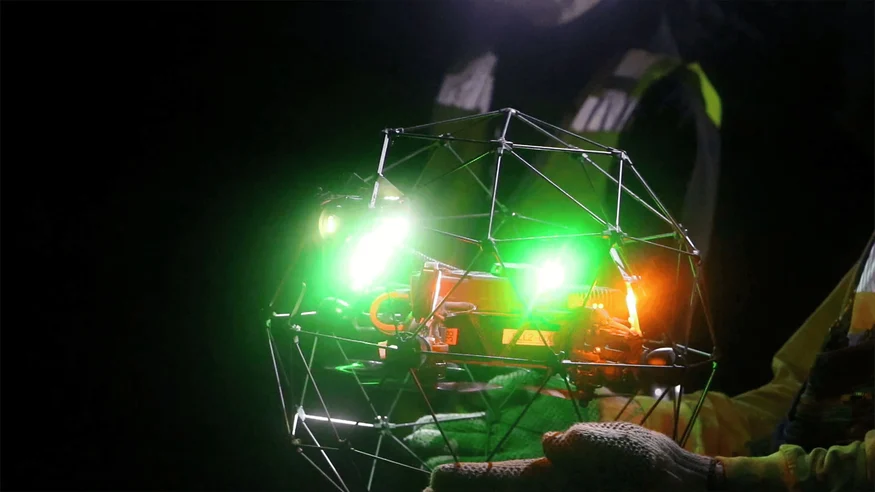
For three days, Flyability’s Elios 2 was tested at Barrick Gold Corporation’s Golden Sunlight Mine in Whitehall, Montana. This compact, rugged drone is built for confined space inspections and proved its worth in an underground setting.
Matt Mackinnon, founder of Unmanned Aerial Services, Inc., who specializes in underground inspections, advised on the development of the Elios 2. His goal was to show how the drone could enhance safety and provide critical visual data during mining operations.
The results exceeded expectations. “The Elios 2 checks nearly every box for what we need to conduct safe and effective underground inspections,†he said. Using data from the drone, the team created a 3D photogrammetric model of a stope—removing ore veins and revealing important geological details.
This data helps mining teams assess the current state of the stope, identify loose material, and locate remaining ore or geotechnical features, all while improving safety and efficiency.
Customer Needs
After blasting, large rocks can hang inside a stope, posing serious risks. These materials can fall unexpectedly, damaging equipment and endangering workers. Traditional methods like lowering cameras or using poles offer limited access, making it hard to fully inspect the area.
Without proper visual data, miners face safety risks, and expensive equipment like muckers can be damaged. Additionally, ore loss due to undetected deposits or waste material mixing with ore can lead to significant financial losses.
When an ore pass becomes clogged, identifying the cause is crucial. Barrick needed a reliable way to gather visual data to create a detailed 3D map of the stope, ensuring safety, protecting equipment, and optimizing ore recovery.
[Related read: What is a LiDAR drone?]
Solution
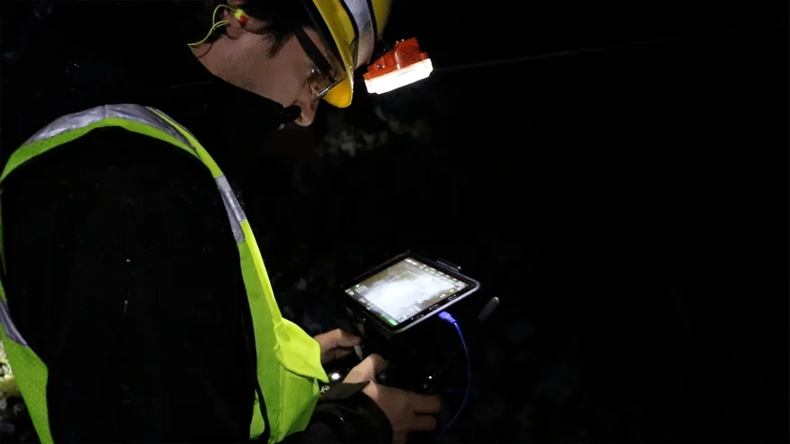
The Elios 2 was deployed across multiple stopes at the Golden Sunlight Mine. Ryan Turner, a geotechnical engineer at Barrick, oversaw the missions alongside Matt Mackinnon and the Flyability team.
“It's a drone you can take off the shelf and fly in one of the harshest environments,†Turner said. “It captures quality footage, is safe to use, and the cage protects people, objects, and itself.â€
Results
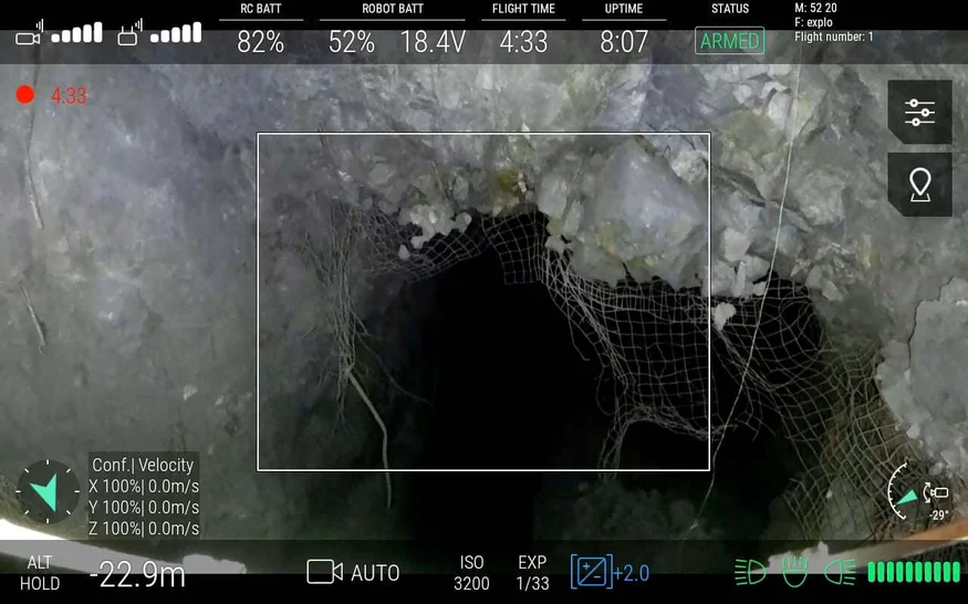
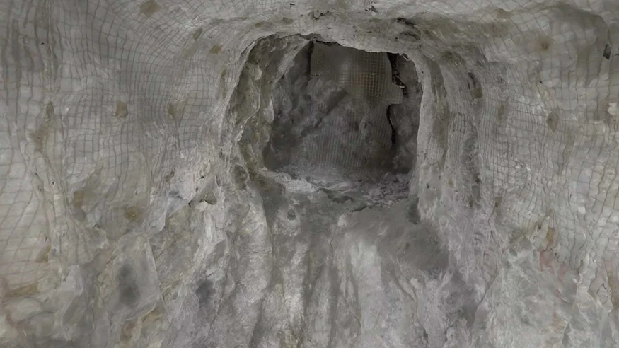
The Elios 2 successfully navigated both large spaces and tight shafts, capturing high-quality data that surpassed traditional methods. Its lighting system illuminated even the largest areas, and the protective cage prevented damage during collisions with wires and support structures.
The drone revealed mixed material on the stope floor and provided clear images of geological structures releasing debris. This data enabled Turner to conduct accurate stability analyses and risk assessments.
“The imagery looked really good,†he said. “We were able to see where structures were releasing material.â€
Additionally, the Elios 2 captured the position of large boulders and the condition of loose material above mucker operations, helping determine if personnel and equipment were at risk.
One standout feature was how easy it was to fly. Even employees with no prior drone experience were able to operate the Elios 2 effectively. In three days, five drones were flown without any loss, a rare success in underground mining.
“You can hand it to someone who’s never used it, and they’ll be successful,†Turner noted.
Photogrammetric Mapping – Testing and Development
In addition to real-time data, four flights provided enough information to create a 3D photogrammetric model of a stope using Pix4D Mapper. These models offer a snapshot of the site’s condition and reveal the full volume of the excavation.
Geotechnical engineers can use these maps to compare before-and-after conditions, track rock movement, and perform stability analyses. Clicking specific points on the model allows inspectors to view original images and examine geological features in detail.
These models help engineers plan future operations, optimize ore recovery, and reduce risks by identifying potential hazards early.
Conclusion
The Elios 2 has transformed how mining companies like Barrick Gold and UAS Inc. access and analyze underground sites. With its ability to collect precise data and create 3D models, the drone enhances safety, reduces risk, and improves decision-making.
By enabling detailed inspections and photogrammetric mapping, the Elios 2 helps maximize production, prevent equipment damage, and ensure the safety of both personnel and machinery. It represents a major advancement in underground mining technology.
This article is part of a series on photogrammetry:
- Why use photogrammetry to build 3D models of indoor spaces?
- Mining drones: Elios 2 creates photogrammetric models
- Building 3D models with Elios 2: How to acquire appropriate data for photogrammetry
- Building 3D models with Elios 2: Processing data with photogrammetry software
- Elios 2 Tested for Indoor Stockpile Volumetry, Produces 3D Maps Accurate to within 1 Centimeter
FZ Filter Membrane filtration media is another kind of liquid filter media, it`s mainly used for producing Membrane Pleated Filter Cartridges. We supply many kinds of membrane filtration media with different filtration rate, which can meet our customers` needs to make filter cartridges with various filtration accuracy. We also provide Reverse Osmosis Membranes, which are widely used in fields of municipal water supply, power plant, chemical plant, food&beverage and domestic water supply. Our wide range of technologies and extended know-how in all liquid-related sectors will guarantee you a cost-efficient solution meeting your liquid quality requirements.
Membrane Filtration Media,Polypropylene Microporous Grade Membrane,Polypropylene Microporous Gradeâ…¡ Membrane
Shanghai Feizuo Environment Technology Co,.Ltd , https://www.fzfilter.com